![](/images/other/stat-length.png)
![Trail On foot Montrichard Val de Cher - Amboise - J5 G1 - Montrichard - Photo](https://media.geolcdn.com/t/1900/400/ext.pjpeg?maxdim=2&url=https%3A%2F%2Fstatic1.geolcdn.com%2Fsiteimages%2Fupload%2Ffiles%2F1545311037marcheuse_200dpi.jpg)
Amboise - J5 G1 - Montrichard
Les 1000 pattes
Club randonnées SERVON
![Length](/images/other/stat-length.png)
Length
16.5 km
![Max alt](https://static1.geolcdn.com/siteimages/upload/files/1508320355ic_sort_altitude_max_24dp.png)
Max alt
132 m
![Uphill gradient](https://static1.geolcdn.com/siteimages/upload/files/1508320355ic_sort_den_pos_24dp.png)
Uphill gradient
187 m
![Km-Effort](/images/other/stat-length.png)
Km-Effort
19 km
![Min alt](https://static1.geolcdn.com/siteimages/upload/files/1508320355ic_sort_altitude_min_24dp.png)
Min alt
55 m
![Downhill gradient](https://static1.geolcdn.com/siteimages/upload/files/1508320355ic_sort_den_neg_24dp.png)
Downhill gradient
185 m
![Boucle](https://static1.geolcdn.com/siteimages/upload/files/16400158638029165_repeat_loop_refresh_sync_direction_icon.png)
Boucle
Yes
Creation date :
2023-01-10 15:28:51.365
Updated on :
2023-05-11 14:56:27.201
![On foot](https://static1.geolcdn.com/sitytour/trail-icons/100.png)
4h18
Difficulty : Easy
![Scan this QR Code to open this trail in the SityTrail application](https://capi.geolives.com/qq0zvz2zws4bq2lad0pu/sitytour/trails/3514734/qr.png?size=200)
FREE GPS app for hiking
About
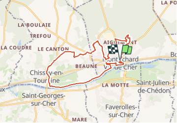
Trail On foot of 16.5 km to be discovered at Centre-Loire Valley, Loir-et-Cher, Montrichard Val de Cher. This trail is proposed by Les 1000 pattes.
Description
Parking Carrefour Express Rue de Blois
Pouvant être raccourcie à la cote 123 sur D 115
Positioning
Country:
France
Region :
Centre-Loire Valley
Department/Province :
Loir-et-Cher
Municipality :
Montrichard Val de Cher
Location:
Unknown
Start:(Dec)
Start:(UTM)
362853 ; 5245001 (31T) N.
Comments
Trails nearby
![Trail Walking Saint-Georges-sur-Cher - Saint-Georges-sur-Cher - GRP Forêt Montrichard - 17.6km 165m 3h40 - 2023 12 27 - Photo](https://media.geolcdn.com/t/375/260/ext.jpg?maxdim=2&url=https%3A%2F%2Fmedia.geolcdn.com%2Ff%2F880c30e7-b6b6-4502-9fce-27a680430128.jpg)
![Walking Walking](https://static1.geolcdn.com/sitytour/trail-icons/101.png)
Saint-Georges-sur-Cher - GRP Forêt Montrichard - 17.6km 165m 3h40 - 2023 12 27
Walking
Easy
Saint-Georges-sur-Cher,
Centre-Loire Valley,
Loir-et-Cher,
France
![](/images/other/stat-length.png)
17.7 km | 19.8 km-effort
3h 40min
![](https://static1.geolcdn.com/siteimages/upload/files/16400158638029165_repeat_loop_refresh_sync_direction_icon.png)
Yes
![Trail Walking Montrichard Val de Cher - bourre GS 2022 deuxième partie - Photo](https://media.geolcdn.com/t/375/260/ext.jpg?maxdim=2&url=https%3A%2F%2Fmedia.geolcdn.com%2Ff%2F213cc68c-99a1-47e7-b571-f46ebff7b935.jpg)
![Walking Walking](https://static1.geolcdn.com/sitytour/trail-icons/101.png)
bourre GS 2022 deuxième partie
Walking
Medium
Montrichard Val de Cher,
Centre-Loire Valley,
Loir-et-Cher,
France
![](/images/other/stat-length.png)
6.2 km | 8.6 km-effort
1h 30min
![](https://static1.geolcdn.com/siteimages/upload/files/16400158638029165_repeat_loop_refresh_sync_direction_icon.png)
No
![Trail Walking Faverolles-sur-Cher - Montrichard - GR41 Forêt GRP - 13.9km 220m 3h30 - 2022 03 03 - Photo](https://media.geolcdn.com/t/375/260/ext.jpg?maxdim=2&url=https%3A%2F%2Fmedia.geolcdn.com%2Ff%2Fe0906f58-3286-4bdf-8af8-a43f3b5ae1bb.jpg)
![Walking Walking](https://static1.geolcdn.com/sitytour/trail-icons/101.png)
Montrichard - GR41 Forêt GRP - 13.9km 220m 3h30 - 2022 03 03
Walking
Easy
Faverolles-sur-Cher,
Centre-Loire Valley,
Loir-et-Cher,
France
![](/images/other/stat-length.png)
13.9 km | 16.9 km-effort
3h 30min
![](https://static1.geolcdn.com/siteimages/upload/files/16400158638029165_repeat_loop_refresh_sync_direction_icon.png)
Yes
![Trail Walking Saint-Georges-sur-Cher - Saint-Georges-sur-Cher - la Rabotière - 5.9km 50m 1h25 - 2021 12 26 - Photo](https://media.geolcdn.com/t/375/260/ext.jpg?maxdim=2&url=https%3A%2F%2Fmedia.geolcdn.com%2Ff%2Fbf0f4dfb-3021-439f-aae4-efd12cf3a4f1.jpg)
![Walking Walking](https://static1.geolcdn.com/sitytour/trail-icons/101.png)
Saint-Georges-sur-Cher - la Rabotière - 5.9km 50m 1h25 - 2021 12 26
Walking
Very easy
Saint-Georges-sur-Cher,
Centre-Loire Valley,
Loir-et-Cher,
France
![](/images/other/stat-length.png)
5.9 km | 6.6 km-effort
1h 25min
![](https://static1.geolcdn.com/siteimages/upload/files/16400158638029165_repeat_loop_refresh_sync_direction_icon.png)
Yes
![Trail Road bike Faverolles-sur-Cher - Balade autour de Montrichard - Photo](https://media.geolcdn.com/t/375/260/ext.jpg?maxdim=2&url=https%3A%2F%2Fmedia.geolcdn.com%2Ff%2Fc4096268-dc86-4418-be06-564534f0f851.jpg)
![Road bike Road bike](https://static1.geolcdn.com/sitytour/trail-icons/201.png)
Balade autour de Montrichard
Road bike
Medium
Faverolles-sur-Cher,
Centre-Loire Valley,
Loir-et-Cher,
France
![](/images/other/stat-length.png)
48 km | 54 km-effort
3h 38min
![](https://static1.geolcdn.com/siteimages/upload/files/16400158638029165_repeat_loop_refresh_sync_direction_icon.png)
No
![Trail Walking Saint-Georges-sur-Cher - Saint-Georges-sur-Cher - Montfourgon - 10.1km 110m 2h25 - 2021 01 02 - Photo](https://media.geolcdn.com/t/375/260/ext.jpg?maxdim=2&url=https%3A%2F%2Fmedia.geolcdn.com%2Ff%2Ff115f6ef-46e3-4de7-a2db-116f89709983.jpg)
![Walking Walking](https://static1.geolcdn.com/sitytour/trail-icons/101.png)
Saint-Georges-sur-Cher - Montfourgon - 10.1km 110m 2h25 - 2021 01 02
Walking
Very easy
Saint-Georges-sur-Cher,
Centre-Loire Valley,
Loir-et-Cher,
France
![](/images/other/stat-length.png)
10.2 km | 11.6 km-effort
2h 25min
![](https://static1.geolcdn.com/siteimages/upload/files/16400158638029165_repeat_loop_refresh_sync_direction_icon.png)
Yes
![Trail Walking Saint-Georges-sur-Cher - Saint-Georges-sur-Cher - barrage de castors - 10km 130m 2h10 - 2020 12 26 - Photo](https://media.geolcdn.com/t/375/260/ext.jpg?maxdim=2&url=https%3A%2F%2Fmedia.geolcdn.com%2Ff%2F9d6a7779-3dab-4c71-aee3-1f28b204988e.jpg)
![Walking Walking](https://static1.geolcdn.com/sitytour/trail-icons/101.png)
Saint-Georges-sur-Cher - barrage de castors - 10km 130m 2h10 - 2020 12 26
Walking
Very easy
Saint-Georges-sur-Cher,
Centre-Loire Valley,
Loir-et-Cher,
France
![](/images/other/stat-length.png)
10 km | 11.8 km-effort
2h 10min
![](https://static1.geolcdn.com/siteimages/upload/files/16400158638029165_repeat_loop_refresh_sync_direction_icon.png)
Yes
![Trail Walking Saint-Georges-sur-Cher - Saint-Georges-sur-Cher - boucle bord du Cher - 6.5km 50m 1h35 - 2020 10 04 - Photo](https://media.geolcdn.com/t/375/260/ext.jpg?maxdim=2&url=https%3A%2F%2Fmedia.geolcdn.com%2Ff%2Ff011b49a-c98e-461a-9255-6b51cf3fa752.jpg)
![Walking Walking](https://static1.geolcdn.com/sitytour/trail-icons/101.png)
Saint-Georges-sur-Cher - boucle bord du Cher - 6.5km 50m 1h35 - 2020 10 04
Walking
Very easy
Saint-Georges-sur-Cher,
Centre-Loire Valley,
Loir-et-Cher,
France
![](/images/other/stat-length.png)
6.5 km | 7.2 km-effort
1h 35min
![](https://static1.geolcdn.com/siteimages/upload/files/16400158638029165_repeat_loop_refresh_sync_direction_icon.png)
Yes
![Trail Walking Montrichard Val de Cher - Bourré Dede 07 2020 - Photo](https://media.geolcdn.com/t/375/260/ext.jpg?maxdim=2&url=https%3A%2F%2Fmedia.geolcdn.com%2Ff%2Ff9c7b8d0-4ad0-4c48-94d2-9cdbe63ef3cf.jpg)
![Walking Walking](https://static1.geolcdn.com/sitytour/trail-icons/101.png)
Bourré Dede 07 2020
Walking
Easy
Montrichard Val de Cher,
Centre-Loire Valley,
Loir-et-Cher,
France
![](/images/other/stat-length.png)
16.4 km | 20 km-effort
3h 12min
![](https://static1.geolcdn.com/siteimages/upload/files/16400158638029165_repeat_loop_refresh_sync_direction_icon.png)
Yes